

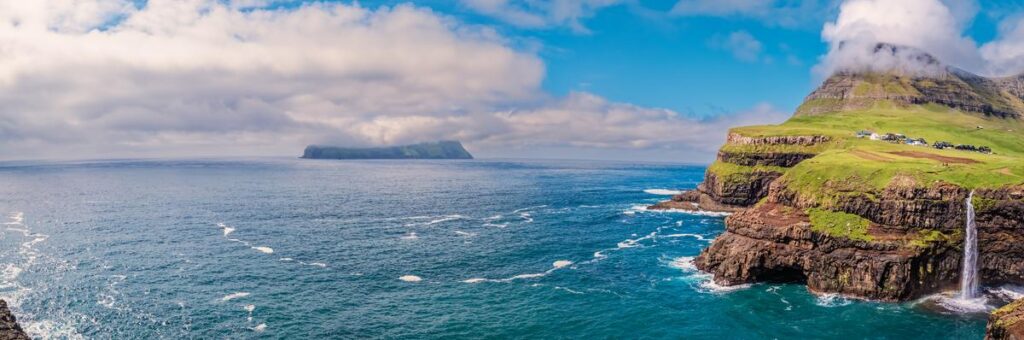
Gásadalur is worth visiting for a striking waterfall viewpoint with very little walking. The village sits below 722-meter Árnafjall, and Múlafossur Waterfall drops from the coastal cliff into the North Atlantic. The official viewpoint is about a five-minute walk from the marked parking area. Most visitors need 45 to 90 minutes for the waterfall and a short village walk; allow longer for lunch or the historic Bøur–Gásadalur trail.
Planning details were last checked on July 22, 2026. Bus timetables, café hours, trail conditions, and access rules can change, so recheck the linked official sources before departure.
Key takeaways
- Main sight: Múlafossur Waterfall, reached by a short marked walk from parking.
- Best visit length: 45 to 90 minutes for the viewpoint and village; half a day if you add lunch and Bøur.
- Easiest access: Rental car, taxi, or guided tour. In 2026, public Route 350 has limited weekday service and is listed only through August 28.
- Longer hike: The old Bøur–Gásadalur route is officially rated difficult, covers 3 kilometers one way, and has steep, exposed sections.
- Safety: Stay on marked paths, remain inside fences, and do not descend toward the water. The cliff terrain is steep and dangerous.
- Weather: Conditions can shift quickly in every season. Bring waterproof layers even in summer.
Plan your visit
- Gásadalur at a glance
- Why visit Gásadalur?
- How to visit Múlafossur Waterfall
- How to get to Gásadalur
- The Bøur–Gásadalur hike
- Best time to visit
- Food and accommodation
- Nearby stops and a half-day plan
- Frequently asked questions
Gásadalur at a glance
| Planning detail | What to know |
|---|---|
| Location | Western Vágar, Faroe Islands |
| Main attraction | Múlafossur Waterfall and the coastal viewpoint |
| Viewpoint walk | About five minutes from marked parking |
| Typical visit | 45 to 90 minutes, excluding a meal or long hike |
| Road access | The tunnel opened in 2004, ending the village’s road isolation |
| Public transport | Limited, seasonal weekday Route 350 service in the 2026 timetable |
| Long hike | Bøur–Gásadalur: 3 km one way, about 1 hour 5 minutes moving time, difficult |
| Facilities | Marked parking, public toilets, a café, and a small amount of accommodation |
Why visit Gásadalur?
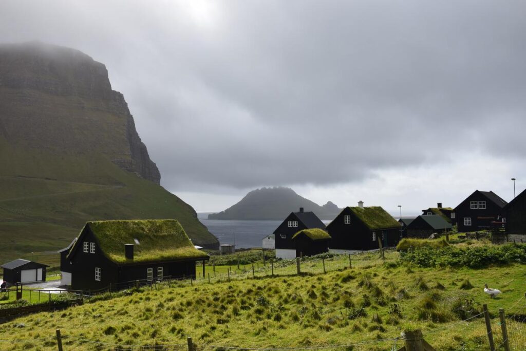
Gásadalur combines three features that are hard to find in one short stop: a compact Faroese village, a waterfall that falls directly from a sea cliff, and broad views toward Mykines. Árnafjall, the highest mountain on Vágar at 722 meters, rises above the settlement.
The village also has a distinctive transport history. Before the road connection, residents relied on the mountain path, boats, and later helicopter service. According to the official Gásadalur visitor information, the tunnel completed in 2004 connected the village to the rest of Vágar by road and ended its isolation.

Gásadalur is still a lived-in farming village, not a purpose-built attraction. Keep noise low, avoid private yards, leave gates as you find them, and give residents and working vehicles room to pass.
How to visit Múlafossur Waterfall
Parking and the viewpoint walk
Drive through the tunnel into Gásadalur and use a marked parking area. Do not block a driveway, farm entrance, gate, or passing place. From the official parking area, follow the signed path to the viewpoint; Visit Vágar describes the walk as about five minutes.
The standard viewpoint gives the familiar composition of Múlafossur in the foreground and the village behind it. You do not need to descend the cliff or cross a fence for the view. The official guidance is explicit: respect signs, stay on clear paths, and remain inside fences and markings because the surrounding terrain is steep and dangerous.
How much time to allow
- 30 to 45 minutes: Park, walk to the viewpoint, take photos, and return.
- 60 to 90 minutes: Add a quiet walk through the public lanes of the village.
- Two to three hours: Add lunch or coffee, with a buffer for changing weather.
- Half a day or longer: Pair Gásadalur with Bøur or complete the old mountain trail with return transportation arranged in advance.
Safety and photography
Wind, rain, mist, and sea spray can make the path slippery and reduce visibility. Wear shoes with grip, secure loose gear, and keep children close. If wind makes it difficult to stand steadily, leave the cliffside path and wait for better conditions.
For photography, a wider focal length helps include the waterfall, cliff, and village. A microfiber cloth is useful for spray. The safest composition is the marked viewpoint; no photograph justifies crossing a fence or approaching an unprotected edge.

How to get to Gásadalur
By rental car
A car is the most flexible option. Gásadalur is roughly a 15- to 20-minute drive from Vágar Airport in normal conditions, following the road west through Sørvágur and Bøur. The final approach passes through a narrow tunnel. Drive slowly and follow the posted priority, lighting, and passing-place signs.
Because the village is close to the airport, it works well as a first stop after arrival or a final stop before returning a rental car. Build in extra time for fog, wind, road work, and slow traffic.
By public bus
Public transport is possible on selected dates, but it is not frequent enough for an improvised visit. The 2026 Route 350 timetable lists weekday service between Tórshavn, Vágar Airport, Bøur, and Gásadalur, with seasonal validity through August 28. The number of departures is limited, and service patterns change between school and summer periods.
Check the outbound and return times on the same day, then leave a generous connection buffer. Outside the published service dates—or on weekends—a taxi, rental car, or tour is the safer plan.
By guided tour
A tour is useful if you do not want to drive narrow roads or need transportation from Tórshavn. Choose one that names Gásadalur and Múlafossur in the itinerary, states the group size and pickup point, and leaves enough time at the viewpoint rather than treating it as a brief photo stop.
Affiliate disclosure: ViaTravelers may earn a commission if you book through the link below, at no additional cost to you. Availability, itinerary, and price are controlled by the tour operator.
The old Bøur–Gásadalur mountain trail
The historic route over the mountain is a real hike, not an extension of the short waterfall walk. Visit Faroe Islands rates it difficult and lists a distance of 3 kilometers, an official moving time of about 1 hour 5 minutes, a high point of 434 meters, and 304 meters of elevation.
Those figures describe the route one way. Most travelers should budget 1.5 to 2 hours one way after allowing for pauses, route-finding, and photos. Arrange the return before starting. Do not assume a bus will match your finish time, and do not treat the road tunnel as an assumed pedestrian shortcut.
Who should attempt it?
- Good fit: Hikers comfortable with steep grass, exposure, loose stones, wet ground, and fast-changing weather.
- Think carefully: Anyone uneasy near unprotected drops, carrying a heavy pack, or relying on a strict bus connection.
- Skip it: Travelers in poor visibility, strong wind, unsuitable footwear, or with small children. The official route guidance says it is suitable for children age 10 and older, but adults should still judge conditions and each child’s experience conservatively.
The first stretch from the Bøur side is steep and runs close to the mountain edge. The descent toward Gásadalur can contain loose stones. Fog can remove both the view and useful visual references, so postpone the hike when visibility or wind is poor.
What you pass on the route
The trail carries more history than the waterfall viewpoint alone. Along the way, hikers pass Líksteinurin, or the “Corpse Stone,” where coffin bearers once rested while carrying the dead from Gásadalur to Bøur. The route also passes the Vívdá spring, Risasporið—the “giant’s footprint” of local legend—and medieval ruins near Gásadalur.
Carry waterproof layers, sturdy boots, water, a charged phone, and the official GPX file or an offline map. Check the current Faroese weather guidance immediately before setting out.
Best time to visit Gásadalur
June through August offers the longest daylight and generally the most favorable hiking conditions, but clear weather is never guaranteed. Summer averages are cool—about 10–13°C—and wind and fog remain common. Visit early or later in the day for a quieter viewpoint, while keeping café and bus hours in mind.
| Season | Typical conditions | Best for | Main tradeoff |
|---|---|---|---|
| Spring (April–May) | About 5–9°C, increasing daylight, unstable weather | Road trips, photography, lighter crowds | Cool, wet paths and abrupt weather shifts |
| Summer (June–August) | About 10–13°C, long daylight, occasional fog and wind | Waterfall visits, hiking, flexible sightseeing | Peak visitor season |
| Autumn (September–October) | About 7–11°C, more rain and changing light | Moody landscape photography | Shorter days and less predictable transport |
| Winter (November–March) | About 3–7°C, short days, Atlantic storms possible | Quiet scenery and a chance of aurora under clear skies | Wind, darkness, closures, and transport disruption |
For the Northern Lights, summer is the wrong season because the nights are too bright. The official Northern Lights guidance recommends late autumn through early spring, especially November to February and sometimes March. Even then, an aurora requires darkness, clear skies, and suitable solar activity.
Where to eat and stay
Gásadalsgarður Café
Gásadalsgarður serves Faroese open sandwiches, fish, cakes, coffee, and other light meals. At the time of verification, the café listed opening hours of 11:00 a.m. to 4:00 p.m. and warned that changes can occur. Check its website or social channels before making the café central to your plan.
Carry water and a backup snack, especially outside summer, when using the bus, or when hiking. Do not build a tight transport or hiking plan around café service without confirming the current hours.
Where to stay
- Gásadalur: Best for quiet mornings, evening light, and immediate access to the waterfall. Inventory is limited. The official listing for Múlafossur Cottages says the cottages sleep four to six people and require stairs or a ladder to reach the upper level.
- Sørvágur or Miðvágur: Better for groceries, airport access, and an early departure for Mykines or other Vágar activities.
- Tórshavn: Better for travelers who prioritize a wider choice of restaurants and a central base for several islands, but it adds driving time to a Gásadalur visit.
Nearby stops and a practical half-day plan
A simple half-day itinerary
- Stop in Bøur for 20 to 30 minutes. Walk only on public lanes and look across Sørvágsfjørður toward Tindhólmur and Gáshólmur.
- Continue through the tunnel to Gásadalur. Allow 45 to 90 minutes for the Múlafossur viewpoint and village.
- Add lunch or coffee. Check Gásadalsgarður’s current hours before relying on it.
- Choose one additional Vágar stop. Visit the Trøllkonufingur viewpoint near Sandavágur, or reserve several hours for the paid Leitisvatn/Sørvágsvatn and Trælanípa trail. Do not try to compress both into a rushed airport-day schedule.
What about Mykines and puffins?
Do not plan Gásadalur as a dependable close-range puffin stop. Birds may be present around Vágar, but sightings are not guaranteed. For a dedicated puffin trip, Mykines is the better-known choice. The official Mykines transport information says the ferry normally runs from Sørvágur from May 1 through August 31 when weather permits, while the ferry operator’s FAQ identifies May to mid-August as the best puffin period.
Mykines should be a separate, weather-dependent day rather than a quick addition to Gásadalur. Buy transport in advance, read the current island access guidance, and keep a backup plan because sailings can be canceled.
Responsible visiting and safety
- Use marked parking and keep farm entrances, driveways, and passing places clear.
- Stay on signed paths and inside fences around Múlafossur.
- Leave livestock gates as you find them and never chase or feed animals.
- Keep away from cliff edges in strong wind, fog, or slippery conditions.
- Do not enter private yards, porches, fields, or farm buildings for a photograph.
- Pack out litter and keep voices low near homes.
- Check current weather, road, bus, and trail information before leaving.
Is Gásadalur worth visiting?
Yes—especially on a first trip to Vágar. Gásadalur offers a distinctive landscape, meaningful local history, and a short route to Múlafossur that fits easily into an arrival day, departure day, or wider island drive. It is less suitable as a primary puffin destination, and the old trail is a poor choice in bad weather or for inexperienced hikers.
For a wider route through the archipelago, use the ViaTravelers Faroe Islands travel guide to connect Gásadalur with other islands, villages, hikes, and transport planning.
Frequently asked questions
How long do you need in Gásadalur?
Most visitors need 45 to 90 minutes for the Múlafossur viewpoint and a short walk through the public village lanes. Allow two to three hours if you add lunch, and at least half a day if you include Bøur or the old mountain trail.
How far is Múlafossur Waterfall from the parking area?
Visit Vágar describes the signed walk from the marked parking area to the viewpoint as about five minutes. Weather, mobility, and photo stops can make it take longer.
Can you get to Gásadalur without a car?
Yes, but options are limited. The 2026 Route 350 timetable lists selected weekday service through August 28. Check the same-day outbound and return schedule; otherwise arrange a taxi or guided tour.
Is the Bøur–Gásadalur hike easy?
No. The official route is rated difficult. It is 3 kilometers one way and includes steep, exposed ground and loose stones. Attempt it only with suitable footwear, good visibility, and a confirmed return plan.
Can you see puffins in Gásadalur?
Puffins may appear around Vágar, but Gásadalur is not a dependable close-viewing site. For a dedicated puffin trip, Mykines is the better-known option; ferry trips are seasonal and weather-dependent.
Can you see the Northern Lights in Gásadalur?
Yes, when skies are dark and clear and solar activity is favorable. The best period is generally November through February, sometimes extending into March. Summer nights are too bright for reliable viewing.